Commemorating Earth Day in Hopkins Forest provides the opportunity for a look into a relatively little known episode of forest history. This stems from a coincidence of timing. The first Earth Day was observed in 1970, and though the holiday garners diverse reactions today — ranging from celebration, to apathy, to upset at the reminder of our sluggish response to global climate change —it was initially conceived of as a day of education and protest for the nascent climate movement. 1970 was also the year of a meeting between Professor Emeritus of Biology Hank Art — then still young, and, as he says, “wet-behind the ears” — and the Pacific Northwest logging tycoon, Prentice Bloedel, a meeting which shaped the fate of the Hopkins Forest.
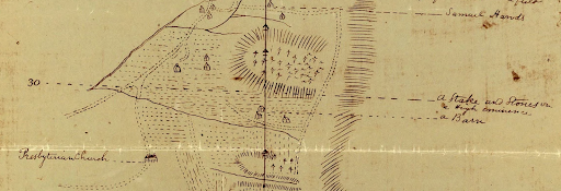
The story emerges from a trove of maps now held by Special Collections which examine and represent Hopkins Forest across history from nearly every angle and intricacy. The maps are available online through Williams Unbound, and provide a wonderful pastime for the cartographically inclined: they are a fabulously diverse, often beautifully hand rendered, and sometimes deeply strange trove of documents dating as far back as the 1700s; and, for the careful reader, they contain a wealth of information about the forest’s history of use and potential use, illustrating both the Hopkins we recognize today and plans for the land which never came about.
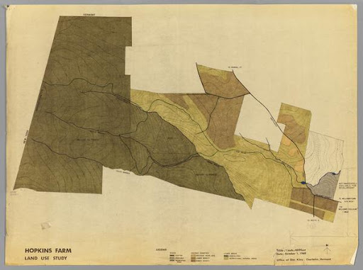
While much about this collection is engaging, when I first browsed it a cluster of maps from the years leading up to 1970 particularly jumped out. One, from 1969 and drawn up by Peter P. Welanetz — then an employee in the college’s building and grounds department — is titled “Disposal Plan for Liquidating the Hopkins Memorial Forest (Draft).” Another, from the office of famed landscape architect Dan Kiley in the same year, is titled “Hopkins Farm — Proposed Development.” The more innocently titled map “Hopkins Farm, Land Use Study,” reveals upon close inspection three shades of green dividing up the entirety of the forest into areas of “higher density,” “lower density,” and “individual house lots:” three different levels of development. For someone who has only ever known of the forest as a place beloved for recreation and study, for both students and the community — a piece of land whose conservation was a sure thing, a fact as old as time — I was blind-sided to learn that fifty years ago the college was considering selling it off for housing. And yet, the maps show such plans in full: some even reveal that Forest Road, a small cul-de-sac off Bulkeley Street is the legacy of these ‘liquidation’ plans. Once a part of the forest, the land was sold by the college to developers with the assumption that a large portion of the forest would soon follow the same fate.
What precipitated these plans was the exodus of the U.S. Forest Service from Hopkins Forest in 1968. The college had leased the lands to the federal government for management and research for nearly half a century, and when the Forest Service was ready to move on, the college was again faced with the burden of the forest’s management. Only a year before, the Department of Environmental Studies had been founded, and one of its first hires, Biology Professor Henry Art, who retired only last year, was faced with finding the department a field research station. Professor Art’s knowledge of those days enriches the story told by the maps. When he approached the provost of the college about the possibility of using Hopkins Forest for research, he was told, as he recalled in an interview, that the college “had other plans for the land.”
Those plans are exactly as laid out in a 1969 map: the uppermost slope of the forest would be donated to an existing state park and the core of the forest would be sold to Prentice Bloedel, the heir of a logging fortune from Washington State, who “thought the best thing to do would be to purchase the several hundreds acres and build a hunting lodge that he was going to run for his friends,” stocked with cougar, beaver and wildlife of all sorts, Art remembered. Motivated by a demand from faculty for more accessible housing, the college planned to sell off all the remaining land to developers. Moreover, Art attested, the College “just didn’t want to have this big white elephant on their hands” — that elephant being the forest’s gargantuan 1,400 acres.
The maps in the forest archive, of course, are a testament to the fact that these development plans never came to pass: from the half a century after 1970 the archive contains not records of subdivision but dozens of different sketches and summaries of thesis projects, professor research, recreation paths, educational programs and other uses as diverse and colorful as the maps themselves. This turn of events hinged, Art remembered, “on a meeting I had with Prentice Bloedel. Still a brand new faculty member, I went to the house that Prentice was renting in Williamstown and my mission was to tell him what I had in mind for an academic and research station in the forest, and plea with him not to purchase what he had an option on.” Prentice, to his credit, enthusiastically agreed.

One of the great legacies of the Environmental Center thus came about in one of its first years of operation, as it preserved the Hopkins Forest for both student and community education and recreation, a gift which bears fruit to this day. The preservation of the forest thus came about through an attitude towards land which placed education, conservation and communal investment over profit and subdivision — a combination which makes it well placed alongside the rise of Earth Day. Of course, the crisis in affordable housing has only become more difficult in Williamstown in the intervening decades, and questions of land ownership and conservation more complex — and sometimes dubious — in light of increased attention towards settler colonialism and indigenous displacement. Rather than a lesson in easy solutions, the story of Hopkins’ preservation should be understood as a victory for advocacy and communal investment and benefit in our approach to land use and the environment as a whole. It is also, being the season of Earth Day — the moment of spring and of birdsong, of pale green revival in the undergrowth — as good a time as any to walk the Lower Loop with special gratitude for and rededication to a place which might, on other days, be taken for granted.
— Gavin McGough, Williams ’22
Megamenu Social